Uncategorized

Séismes au Venezuela : Des milliers d’enfants en danger

Country: Venezuela (Bolivarian Republic of) Source: UN Children’s Fund CARACAS/NEW YORK, le 25 juin 2026 – Selon les estimations, près de 3,9 millions d’enfants vivent dans les zones touchées par les puissants séismes de magnitude 7,5 et 7,2 qui ont frappé le Venezuela le 24 juin, exposant ainsi des milliers d’enfants et de familles à des risques immédiats. Les secousses ont affecté des communautés à Caracas, ainsi que dans les États d’Aragua, de Carabobo, de Falcón, de La Guaira, de Miranda et alentour. Dans les zones les plus durement touchées, des dizaines de bâtiments se sont effondrés, et selon les premières informations disponibles, des enfants figureraient parmi les victimes. Alors que les autorités poursuivent leurs évaluations, les rapports font état de dégâts concernant les habitations, les infrastructures publiques et les services essentiels, tandis que les populations restent exposées au risque de répliques. « Les images qui nous parviennent du Venezuela et les témoignages de nos collègues sur le terrain sont bouleversants », a déclaré Catherine Russell, Directrice générale de l’UNICEF. « Nos pensées accompagnent les enfants et les familles qui ont perdu des proches, ainsi que toutes celles et tous ceux dont la vie a été brutalement bouleversée. À mesure que l’ampleur de la catastrophe se précise, la sécurité, la protection et le bien-être des enfants doivent rester au cœur de la réponse humanitaire. » Dans les situations d’urgence, les enfants figurent parmi les personnes les plus vulnérables. Dans les heures et les jours à venir, les enfants touchés par ces tremblements de terre risquent non seulement d’être blessés, déplacés ou séparés de leur famille, mais également d’être confrontés à une détresse psychologique importante et à des perturbations dans l’accès aux soins de santé, à l’eau potable, à l’éducation et aux services de protection. À mesure que les évaluations se poursuivent, des milliers de familles auront besoin d’une aide d’urgence. Il est en effet probable que des logements, des écoles, des établissements de santé, des réseaux d’approvisionnement en eau et d’autres infrastructures critiques aient été endommagés, une situation qui risque de limiter l’accès aux services essentiels et d’accroître les risques pour les enfants et les personnes qui s’occupent d’eux. L’UNICEF travaille en étroite coordination avec les autorités nationales et ses partenaires afin d’évaluer les besoins des populations touchées et de soutenir les interventions visant à garantir l’accès des enfants et des familles aux soins médicaux, aux services de protection, au soutien psychosocial, à l’eau potable et à des espaces sûrs. Présent sur le terrain, l’UNICEF réaffirme son engagement à appuyer les efforts nationaux pour répondre aux besoins des enfants touchés et de leurs familles, en accordant une attention toute particulière aux plus vulnérables. Avant les tremblements de terre, l’appel de l’UNICEF au titre de l’Action humanitaire pour les enfants en 2026 au Venezuela s’élevait à 137,6 millions de dollars É.-U., dont seuls 35 % avaient été financés. #####

Séismes au Venezuela : Des milliers d’enfants en danger Read More »

DR Congo: As Ebola spreads in Eastern DRC, WFP warns food, livelihoods and access are critical to containing the outbreak

Country: Democratic Republic of the Congo Source: World Food Programme This is a summary of what was said by the World Food Programme’s (WFP) Country Director for the Democratic Republic of the Congo (DRC), David Stevenson, to whom quoted text may be attributed – at a press briefing in Geneva today. GENEVA/KINSHASA – Thank you, and good morning. Let me start with the bigger picture. Ebola is spreading in eastern DRC in the middle of one of the world’s largest hunger crises. Across the country, 26.5 million people — almost one in four Congolese — do not have enough food. More than 3.6 million people are already facing emergency levels of hunger. And in North Kivu, South Kivu, Ituri and Tanganyika alone, nearly 10 million people are struggling to put food on the table. So this outbreak is not only a health emergency. It is a humanitarian crisis. And we will not contain it with medical measures alone. When people are hungry, when they have lost their livelihoods, or when markets stop functioning, they move. They move to find food. They move to find work. They move to find safety. And those movements can make it much harder to stop the virus. At the same time, active conflict is pushing people into affected health zones. And insecurity and access constraints are making it harder for humanitarian teams to reach the communities who need help most. I want to give you one example. Our frontline team recently met Jacques, an internally displaced father whose five-year-old daughter died from Ebola. He had fled fighting in Bukavu and walked for days to reach Beni. He thought he had escaped the worst. Then his daughter developed a high fever and started bleeding from her ears. He rushed her to hospital, but she did not survive. Two weeks later, his wife is still in an isolation centre. WFP is providing hot meals there so patients and contacts can stay under observation — without having to leave to look for food. Jacques is now caring for their 13 family members with WFP food assistance. But he asked us a very simple, very painful question: “With all these children, this one-month ration will only last two weeks. After that, how am I supposed to feed them when I have no means to do so?” That is why food assistance is not separate from the Ebola response. It is part of containment. It helps people stay in care. It helps contacts remain under observation. It reduces the pressure on families to move. And it gives health teams the time and space they need to do their work. We are also seeing the economic pressure build. In Bunia, the epicentre of the outbreak, families already hit by conflict, displacement and hunger are facing another shock. Border closures, movement restrictions and trade disruptions linked to Ebola are driving up food and fuel prices. WFP has moved quickly. Since the outbreak began, we have provided more than 36,000 hot meals in Ebola treatment centres, take-home rations to 2,600 in North Kivu and Ituri, and monthly food to 14,000 people in ten quarantined villages in South Kivu affected by the outbreak. Our logistics teams and UNHAS flights have also been central to the wider response; moving more than 1,750 first responders and more than 300 metric tons of essential cargo, so frontline operations can keep going in hard-to-reach areas. But we need to do more – and we need to do it faster, at scale, and with the resources required. We need safe and sustained access. We need to stabilize food and livelihoods, so people are not forced to move simply to survive. And we need timely, flexible funding to keep food assistance, supply chains, logistics and aviation support running for as long as this crisis demands. WFP now requires USD72 million for our direct Ebola response and USD286 million for emergency food assistance across eastern DRC. For families like Jacques’, this is very real. Food helps keep people in care. Logistics keep responders moving. Access turns plans into action. If we move quickly now, we have a better chance of containing Ebola — and preventing an already severe humanitarian crisis from getting worse. Thank you. # # #

DR Congo: As Ebola spreads in Eastern DRC, WFP warns food, livelihoods and access are critical to containing the outbreak Read More »

E8e5f035 Ee54 46b3 B6fb Ab81a9f29dd7 MamsNu

Food security under pressure: Impacts of the Middle East Crisis and Pakistan Conflict on Afghanistan (June 2026)

Countries: Afghanistan, Pakistan Source: World Food Programme Please refer to the attached file. Executive summary Afghanistan is facing multiple overlapping shocks. Large-scale returns are straining labour markets, border closures with Pakistan have disrupted trade routes, and the Middle East crisis has pushed up fuel, food and fertilizer prices for an already vulnerable population. Although traders have effectively managed to change supply routes, with 60 percent of trade volume now passing through Iran, costs are increasing. Between October 2025 and April 2026, the cost of the food basket rose by 10 percent while the proportion of households with acceptable food consumption fell from 28 percent to 20 percent. Livelihoods are worsening rapidly, with 72 percent of households reporting income declines and 57 percent relying on crisis-level coping strategies. The combination of trade disruptions, livelihood constraints and limited humanitarian funding is culminating in a nutrition crisis: Afghanistan is already seeing the highest surge in acute malnutrition ever recorded. An estimated 3.7 million children are expected to suffer from wasting in 2026. Under a worst-case scenario of ongoing Pakistan border closure and an escalation in the Middle East, the number of foodinsecure people could rise by an additional 2.3 million over six months, above the current baseline of 13.8 million.

Food security under pressure: Impacts of the Middle East Crisis and Pakistan Conflict on Afghanistan (June 2026) Read More »

Af42d713 8019 4c7f B8e1 302cac9a0daa Yux022

Legacy of conflict in South Lebanon’s soils

Country: Lebanon Source: Amel Association International Please refer to the attached files. Executive summary This report presents the results of a pilot soil monitoring campaign conducted in August 2025 in the Governorate of Nabatieh, South Lebanon. This project – a collaboration between Amel Italia, Amel Association International, and Source International – was initiated in response to widespread concerns among local communities regarding the long-term environmental impacts of the Israeli attacks that began in October 2023. During the August 2025 campaign, we collected 40 topsoil samples across the Marjaayoun and Nabatieh Districts. Results were compared with soil samples collected in 2001 from the same area and with international soil guidelines from Germany and Canada. Across the study area, we observed a statistically significant increase in several metals commonly associated with warfare from 2001 to 2025. Among other metals, lead, antimony, copper, and zinc – well-established markers of military activity – showed clear enrichment across the years. While the median increases were generally moderate, a small number of sites emerged as contamination hotspots, with concentrations far exceeding both historical baselines and international guidelines. Overall, our results reveal a pattern of diffuse, low-to-moderate contamination at the regional scale overlaid by hotspots with markedly elevated metal concentrations – a spatial pattern consistent with observations from other post-conflict settings. In contrast, we found no substantial evidence of soil contamination that can be uniquely attributed to the use of white phosphorus. All proxies of white phosphorus analyzed so far have shown no systematic differences between 2001 and 2025, nor between sites with confirmed white phosphorus strikes and other locations. On the other hand, some sites suspected to be affected by white phosphorus strikes displayed a clear signature of war-related metal contamination. Together, these findings confirm previous investigations suggesting that white phosphorus residues and their degradation products are transient and that the long-term environmental impacts are likely dominated by the toxic metals co-released during explosions, not by white phosphorus itself. Likewise, analysis of total uranium revealed no significant differences between 2001 and 2025. Strong correlations between uranium and phosphorus further support a geogenic, rather than anthropogenic, origin. These results are consistent with a previous national assessment that found no evidence of depleted uranium use in Lebanon. Overall, this first assessment shows a moderate but widespread deterioration of soil quality in South Lebanon over the past two decades. While most sites show limited exceedances, a small number of contamination hotspots pose potential environmental and public-health concerns and warrant priority attention. The findings highlight the need for continued, systematic soil monitoring, targeted investigations at hotspot locations, and integration of environmental assessments into post-conflict recovery and land-use planning.

Legacy of conflict in South Lebanon’s soils Read More »

World: 2026 El Niño Health Risks: Six Extreme Weather Threats Facing the Americas

Country: World Source: Direct Relief Experts weigh in on health risks from extreme weather and what impacted communities across the Americas could see this year. By Olivia Lewis The Atlantic may be seeing a weaker hurricane season than in previous years, but the Americas are bracing for a different kind of threat. The National Oceanic and Atmospheric Administration, or NOAA, issued an El Niño advisory on June 11, with forecasters predicting a 63% chance of sea surface temperatures exceeding averages even more this Fall, to create a “very strong” or Super El Niño. The weather phenomenon occurs when temperatures are warmer than usual in the equatorial Pacific for several consecutive months. While El Niño conditions will likely translate to a below-normal Atlantic hurricane season, it also acts as a chief indicator of long-lived and potentially severe thunderstorms, as well as the possibility for extreme drought in some areas. With extreme weather on the horizon, medical professionals and weather officials are warning the public about severe flooding, extreme heat, and grave health implications for vulnerable populations. Direct Relief spoke with Dr. Ronaldo Similox, a health provider in Guatemala, who has already experienced flooding this year. Similox leads the Guatemalan-based NGO Fundación Margarita Valiente, which receives medical support from Direct Relief, and has been working to provide patient care even during extreme weather events. Here are some of the key impacts that could create health risks this year: Possible Increased Flooding and Coastal Erosion Data compiled by Direct Relief’s Data, Metrics, and Impact team highlights specific regions facing the highest threats from the current El Niño cycle. The heightened temperatures driven by this pattern could easily make 2026 and 2027 the warmest years on record. Regions facing the greatest risk of flooding and coastal erosion include California, the U.S. South, and Southeastern South America. Additionally, NOAA officials reported that heavy rainstorms could originate in the Gulf of the Americas (the Gulf of Mexico) in June and July, with torrential rain expected to fall rapidly, heightening the likelihood of roadway washouts and landslides. Potential Spikes in Respiratory and Gastrointestinal Diseases The drastic shifts in weather could cause torrential rains and flooding, and in those areas, water supplies can quickly become compromised. Dr. Similox of the Guatemalan-based NGO Fundación Margarita Valiente notes that this is particularly dangerous for communities that rely on traditional infrastructure. He warned that there is a high chance of gastrointestinal diseases that spread through consumption of contaminated water, noting that the Mayan people, who predominantly reside in rural areas as agricultural workers, have traditionally relied on well water. Thriving Environments for Vector-Borne Illnesses Stagnant water combined with warmer temperatures can create ideal conditions for the proliferation of mosquitoes, drastically increasing the risk for conditions like Zika, dengue, and chikungunya. According to Dr. Similox, these vector-borne diseases are likely to increase as river waters decrease and become stagnant, leaving vulnerable populations highly exposed as mosquitoes thrive in areas with still water and high temperatures. Severe Malnutrition and Crop Failure in Dry Corridors El Niño doesn’t just cause flooding; it can also drive extreme drought in specific geographic zones. Parts of Guatemala are heavily affected by the Dry Corridor, a strip of land across several Central American countries vulnerable to extreme weather events. Dr. Similox explained that the dual drought-related health threats facing this region are those of respiratory illnesses as well as malnutrition. Because the agricultural community will be subject to drier conditions, respiratory conditions could be aggravated through air pollution and dust. The arid conditions along the strip can also ruin crops and create a scarcity of food. Dr. Similox stated that malnutrition is a top concern among the most vulnerable parts of the population: children, pregnant women, and older adults. Dangerous Inland Flooding Many people associate tropical weather damage strictly with coastlines, but weather data shows that inland cities are often the hardest hit. The last below-normal Atlantic hurricane season occurred in 2015 (also an El Niño year), which brought record rainfall, tornadoes, hailstorms, and record-high temperatures to cities across the United States. For 2026, NOAA officials shared caution for inland cities along the mid-Atlantic and northeastern parts of the United States. CONRED, Guatemala’s risk management organization, has similarly warned its residents of June flood-like conditions affecting roadways. Ken Graham, Director of NOAA’s National Weather Service, stressed during a May 2026 press conference that more than half of storm deaths are caused by inland flooding, noting that people frequently underestimate the power of moving water. “If you live in a flood zone, be prepared for the evacuation plan. Six inches of fast-moving water will knock you off your feet. Twelve inches will carry your car away,” he said. The Critical Forgotten Danger: Medication Scarcity One of the most overlooked health risks during a weather-related evacuation is the sudden loss of access to life-saving prescription medications. When forced to leave their homes quickly, many individuals fail to pack a sufficient supply of their daily medical necessities. Graham warned that preparedness is key, as flood conditions are likely over the next few months, leaving many people unprepared to evacuate for a week at a time. Reflecting on recent disasters, including Hurricane Helene, which saw extreme inland flooding, Graham shared a vital reminder for anyone living in a high-risk weather zone. “The last winter storm event really opened my eyes on something. There were a lot of fatalities of people who didn’t account for medicines,” he said. “We have to remind people over and over that you’re not going to have access to those things for a week at a time or more after a storm.” Direct Relief operates a hurricane preparedness program that prepositions caches of essential medications, including those needed to manage chronic conditions such as diabetes, high blood pressure, and asthma. These caches are placed in storm-prone communities throughout the U.S. Gulf and East Coasts, Caribbean, Central American, and parts of the Pacific. The organization will continue to respond to health needs resulting from extreme weather events around

World: 2026 El Niño Health Risks: Six Extreme Weather Threats Facing the Americas Read More »

7e672428 2562 43cd 999c 22fdf110385f Ci7d06

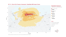
M 7.5 – 28 km SE of Yumare, Venezuela | Shake MMI Impact Zones

Country: Venezuela (Bolivarian Republic of) Source: iMMAP Inc. Please refer to the attached Map. Two major earthquakes struck near Yumare, Venezuela on 24 June — an M 7.2 followed one minute later by an M 7.5, both triggering red USGS alerts. iMMAP’s rapid impact analysis, combining USGS ShakeMap intensity data with WorldPop 2026 population figures, shows the scale of potential exposure: → ~590,000 people in severe to violent shaking zones (MMI VII+) across both events → 4.8 million exposed to strong shaking (VI) from the M 7.5 alone → Over 16 million people within the total earthquake footprint The shaking footprint of the stronger, shallower M 7.5 event extends toward the Valencia–Caracas urban corridor — one of Venezuela’s most densely populated areas — placing significant urban populations within high-intensity zones. The sequential nature of these events compounds the challenge: cumulative structural damage, disrupted access routes, and overlapping needs will shape what an effective response looks like in the hours and days ahead.

M 7.5 – 28 km SE of Yumare, Venezuela | Shake MMI Impact Zones Read More »