
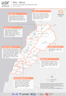

Please refer to the attached Map.
The latest Who–Where map for the Lebanon Emergency Response is now available — covering March to May 2026.
Produced through the H2H Lebanon Information Management Helpdesk, the map tracks 53 local NGOs responding across all eight governorates of Lebanon — from Akkar in the north to South & Nabatiye, and across Beirut, Mount Lebanon, Bekaa, and Baalbek-Hermel.
For humanitarian coordinators, this kind of structured, up-to-date coverage data is essential. It reduces duplication, identifies gaps, and ensures that local organizations — already on the frontlines — can coordinate more effectively.
This map is one of the core outputs of our consortium with CartONG, MapAction, and the Humanitarian OpenStreetMap Team (HOT), supporting the Lebanon Humanitarian Development Forum (LHDF) and its network of over 110 local NGOs — funded by the H2H Network, supported by the Foreign, Commonwealth and Development Office (FCDO).